PROJECT 1
Eritrea, Africa
For my project, I decided to analzye the country of Ertirea. Eritrea is a northeast African country on the Red Sea coast. Eritrea’s location makes it so interesting and in the 20th century, Turkey, Egypt, and Italy all wanted to seize control of Eritrea’s well-located trading ports. The adminsitrative boundary I wanted to focus on within Eritrea, is Debarwa. Debarwa is a market town in Eritrea, and is arguably, the second most popular place in the country aside from the capital, Asmara.
Below is a geometric bar plot I produced, where population density is shown based on county in Eritrea.It makes sense Debub is highly populated, as it is located in the northeast, where most of the trading ports are located. Trading ports facilitate trade, job opportunities, settlements, and thus, a larger population is expected.


This next plot divides the adminsitrative boundaries into further administrative boundaries. As seen, Asmara has a large population, as it is the capital of Eritrea.


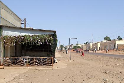
This plot reveals the road networks and infrastructure within Dibarwa. This task was a bit difficult, primarily because there is so much information lacking about the transportation systems within this admistrative boundary. Additionally, since it’s such a developing place, there is not much road infrastrucutre. The one road shown in the plot is the major road highway that travels through Debarwa. Debarwa is a small village, and it only takes about 4 hours to see the whole village on foot. Thus, there are not many well-established road networks theoughout the administrative boundary.

I was able to find a picture of the main road network:
